Neighborhood #1: Far North Side
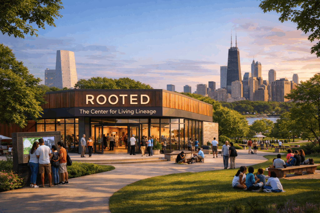
ROOTED: The Center for Living Lineage
Team: Rooted Together
Lead Organization: The Doula, Part Inc.
Zuri Thompson — Lead Visionary and Systems Designer; community investment and cross-sector partnership strategy
Lowell Thompson — Creative Director and Cultural Storytelling Lead; multidisciplinary artist, former advertising creative director, and author
Bobbi Ball — Community Insight and Lineage Research Lead; housing counseling, community development, and intergenerational ancestry research
ROOTED: The Center for Living Lineage proposes a new kind of civic infrastructure for Chicago — not roads or transit or buildings, but a system designed to help residents understand their own place in the city’s history and chart a path forward from it.
The premise is that Chicago’s greatest untapped resource is the identity, history, and potential of its people. For many residents, the connections between personal story and city history remain invisible — fragmented across archives and institutions, disconnected from daily life, and increasingly difficult to transmit across generations as families disperse and community structures erode. ROOTED treats that disconnection as a design problem with a design solution.
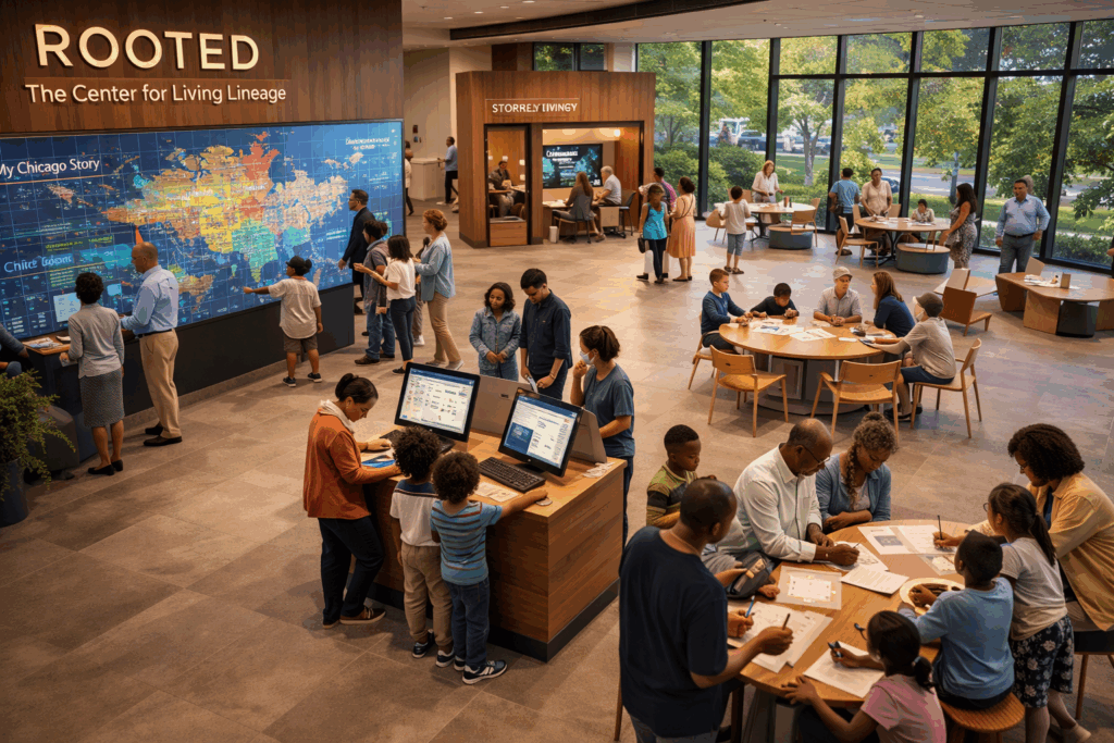
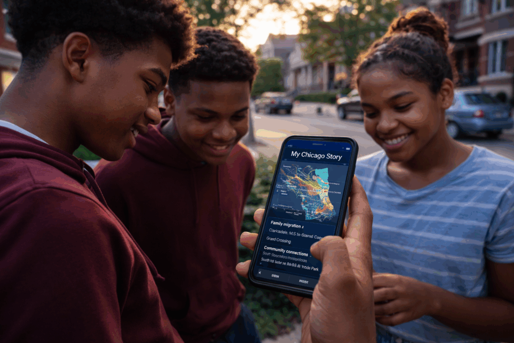
The experience is organized around three questions: How did I get here? What connects me? What do I want to do next? A flagship civic space — ideally anchored on the South Side near the Obama Presidential Center — would guide participants through archival research, interactive storytelling, and data visualization, culminating in a shareable artifact called “My Chicago Story”: a layered personal record of migration, neighborhood history, cultural connections, and future-facing prompts. For seniors, the experience includes a legacy capture component. For families, it becomes a multigenerational visit. For visitors, a tailored pathway positions Chicago as a global reference point for identity and movement.
The flagship extends outward through a distributed citywide network — Chicago Public Library branches, schools, neighborhood hubs, public installations, and digital platforms — embedding ROOTED into the everyday infrastructure of civic life rather than confining it to a single destination.
The proposal is explicit about what it is not building from scratch. Chicago already has world-class cultural institutions, extensive archival systems, and strong community organizations. What is missing is a unifying system that connects those assets to the individual. ROOTED is that connective layer — designed to pilot within three years and scale citywide within a decade, ultimately positioning Chicago as a global model for how cities reconnect people to place, history, and possibility.
Neighborhood #2: Northwest Side
Polonia 2050
Team: Polonia 2050
Lead Organization: Polish Museum of America
Daniel Wozniczka — Team Lead; physician, professor, and originator of the Polonia 2050 concept; vision, strategy, and coordination
Robert Waz — Real Estate Development Lead; President, Altanrow Capital; investment strategy and financial feasibility
Dorian Janowicz — Architectural Design Lead; urban design and streetscape planning
Richard Kniazuk — Finance and Lending Strategy Lead; housing finance and capital access
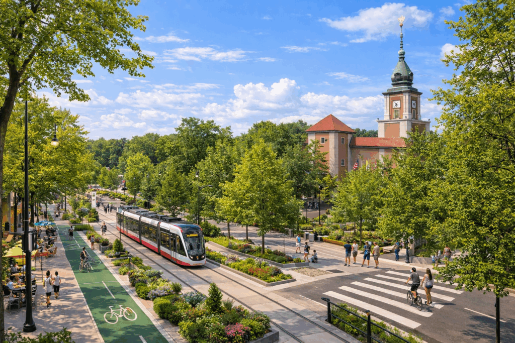
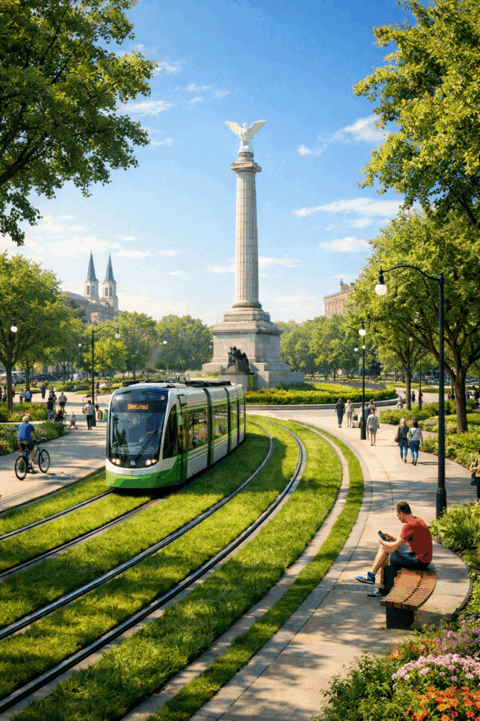
Chicago’s Polish Heritage Corridor proposes transforming Milwaukee Avenue into Chicago’s first European Corridor — a continuous civic landscape stretching from the Polish Triangle in West Town through Logan Square, Avondale, Portage Park, Jefferson Park, and into Niles, unifying what is currently a sequence of disconnected neighborhood segments into a single, legible cultural and economic spine.
The redesign draws on models from Paris, Barcelona, Milan, and Kraków: a street diet that introduces a modern electric green-line tram, expanded pedestrian walkways with café seating, protected bike lanes, tree canopy, community gardens, and space for cultural programming and street performers. Milwaukee Avenue’s diagonal cut across Chicago’s grid — which creates natural nodes where streets intersect — becomes an asset, concentrating activity at points ideally suited for outdoor dining, markets, and public gathering.
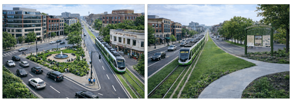
The proposal makes its case across three dimensions. Culturally, it traces the historic path Polish immigrants traveled northwest through Chicago, connecting institutions like the Polish Museum of America, Saint Stanislaus Kostka Church, Saint Hyacinth Basilica, the Copernicus Center, and the Congress Theatre into a unified heritage experience. Economically, it shifts Milwaukee Avenue from a pass-through route to an intentional destination, addressing post-pandemic storefront vacancies and positioning the corridor as a point of entry for transatlantic investment through Chicago’s Polish diaspora networks. Environmentally, the electric tram, expanded green infrastructure, permeable surfaces, and community gardens reframe the corridor as a model for climate-responsive urban design.
Submitted by the Polish Museum of America on behalf of the broader Polish American community, the proposal frames heritage not as something to be preserved behind glass, but as a living force capable of driving the next generation of urban development.
Neighborhood #3: North Side
Chicago Winter Park
Lead Organization: LOO
Elizabeth Tomon, Founder, LOO
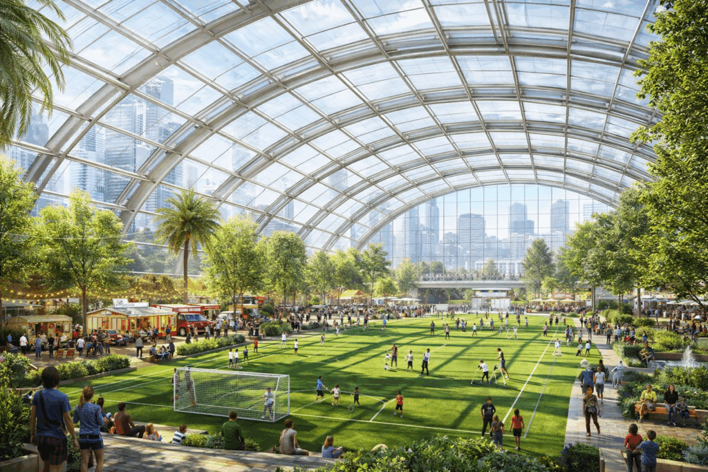
Chicago Winter Park proposes a large-scale, glass-enclosed civic space that gives Chicago a genuine public gathering place for the nearly half the year when weather drives residents indoors — a year-round park designed for everyday life rather than special occasions.
The proposal frames this as a structural gap in Chicago’s public infrastructure. The city has world-class outdoor assets — Millennium Park, the Riverwalk, neighborhood parks — but no central, accessible space that functions consistently through winter, unpredictable shoulder seasons, and increasing climate volatility. The result is a seasonal city: public space that goes underused for months, small businesses that struggle with fluctuating foot traffic, and residents who retreat into isolation during the long cold stretch.
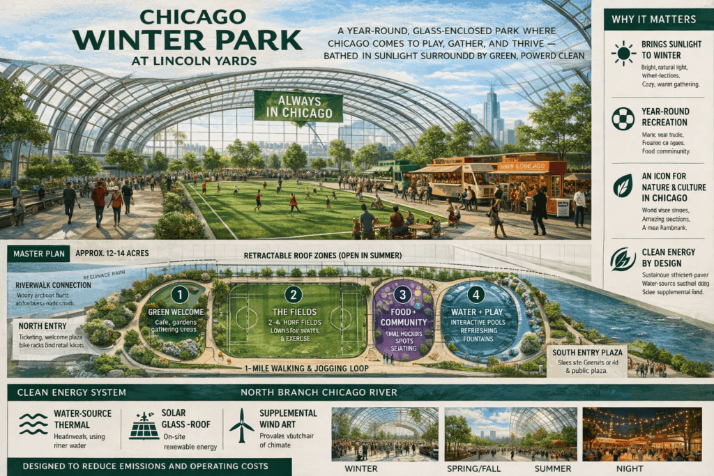
The Chicago Winter Park addresses that gap directly. Conceived explicitly as a civic space rather than a commercial development — the proposal draws the comparison to Millennium Park for the next generation — it would combine recreation, cultural programming, and community gathering under an enclosed structure designed to feel like a park, not a mall. Walking, sports, events, and access to green space in January as easily as July.
The proposal connects its vision to three converging urban challenges: the social cost of rising loneliness, the public health cost of declining physical activity, and the economic cost of seasonal dead zones for local businesses. A permanent, weather-independent civic destination addresses all three simultaneously, giving Chicagoans a reason to stay engaged with public life through the full calendar year.
The concept continues Chicago’s tradition of large-scale civic ambition — reversing the river, rebuilding after the Fire, raising the skyline — applied this time not to infrastructure or architecture for its own sake, but to the more fundamental question of how people actually live together in the city year-round.
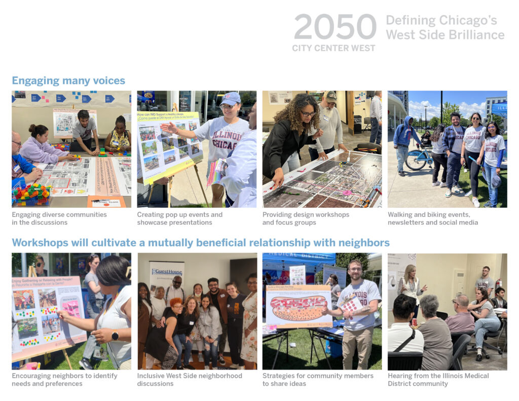
Neighborhood #4: West Side
CITY CENTER WEST 2050
Leading Organizations: University of Illinois Chicago / Illinois Medical District Commission
Co-Leads:
April Jackson, Ph.D. — Associate Professor and Director of City Design, UIC College of Urban Planning and Public Affairs (CUPPA)
Allyson Hanson — CEO & Executive Director, Illinois Medical District Commission (IMDC)
Core Team:
Dimitri Nesbitt — Research Associate, City Design, UIC CUPPA
Philip Enquist, FAIA — Adjunct Professor & Advisory Board Member, UIC CUPPA
Chris Fahey — Director of Real Estate Operations, IMDC
Extended Contributors:
Lim, Justin Heejoon — Assistant Professor, Department of Environmental Design, Seoul National University
Jeannine Colaco / Studio J9 LLC — Graphic Design
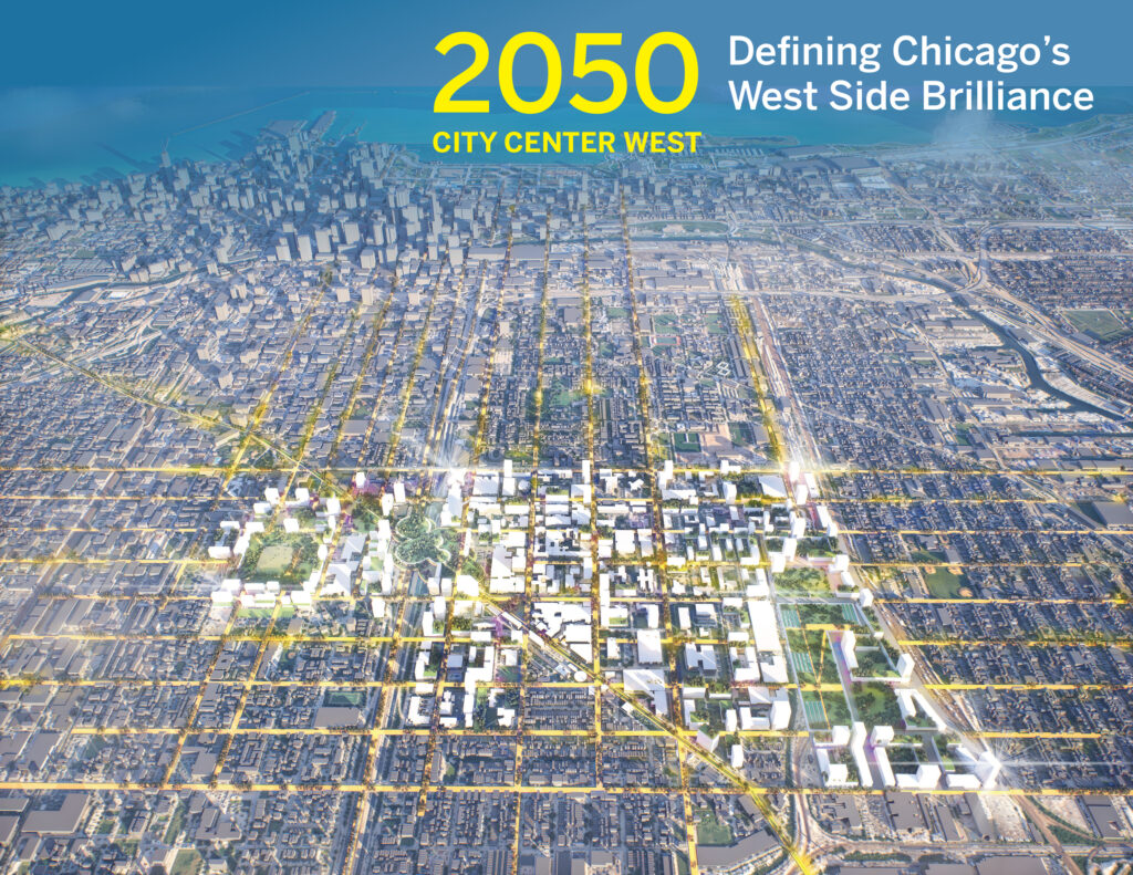
City Center West 2050 envisions the Illinois Medical District evolving into Chicago’s “second downtown” — a 24-hour, walkable, mixed-use urban hub anchoring the West Side and connecting neighborhoods that have long been separated by physical and economic barriers.
The proposal is written from the vantage point of 2050, looking back at a transformation set in motion by a bold 2026 vision. By mid-century, the District has grown from 16 million to as much as 40 million square feet of built space, from 2,000 to over 5,000 housing units, and from 40,000 to more than 80,000 jobs — with annual economic impact surpassing $20 billion.
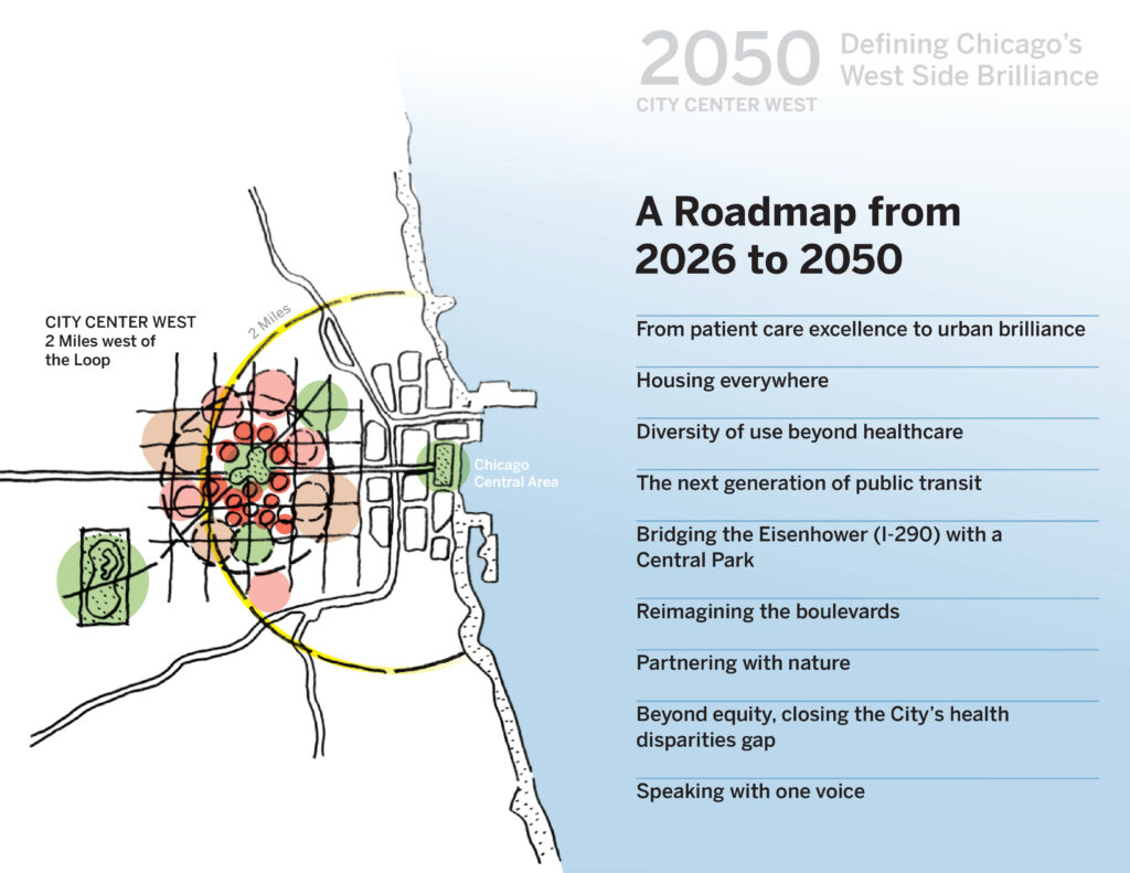
The physical transformation is organized around several interlocking moves. A highway cap over the Eisenhower Expressway at the Blue Line station creates a Central Park linking the District to the United Center and Malcolm X College. Redesigned boulevards give distinct identities to key corridors: Taylor Street as a community dining and culture street connecting Little Italy to Tri-Taylor, Harrison Street as the District’s walkable main street, and the Ogden Diagonal as a green boulevard of linked parks stretching from Goose Island to Douglass Park. New and reimagined Pink and Blue Line stations anchor equitable transit-oriented development throughout.
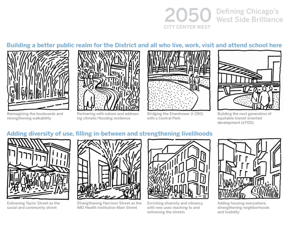
Housing is treated as a citywide obligation rather than an afterthought — affordable, workforce, senior, co-housing, and intergenerational units distributed across the District, including a new mixed-use neighborhood south of Roosevelt Road on land long lost to urban renewal.
The proposal’s most distinctive dimension is its explicit commitment to reparative planning. Recognizing a 20-year life expectancy gap between adjacent Black and white communities, the District’s anchor institutions — UI Health, Rush, and Cook County Health — collaborate on social determinants of health research and community-based wellness investment aimed directly at closing that disparity.
Throughout, the proposal emphasizes that the transformation has been driven by a single, consistent coalition speaking with one voice: neighborhoods, medical institutions, the City of Chicago, and the State of Illinois aligned around a shared long-term vision.
Neighborhood #5: Downtown/ Central
Charlie Henderson Legacy Park: A Community Music & Culture Space
Lead Organization: Out Of The Past Records
Annisa Gooden — Project Lead
Marie Henderson — Owner, Out Of The Past Records
Charlie Joe Henderson — Founder, Out Of The Past Records (deceased)
Local DJs, artists, and community members — Programming and community engagement
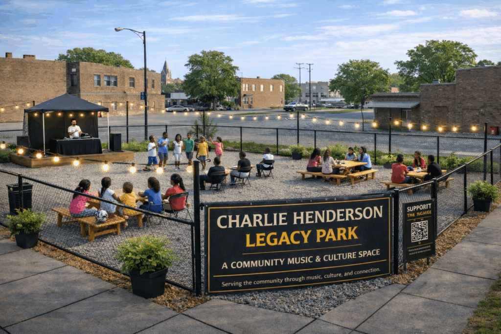
Charlie Henderson Legacy Park proposes transforming a vacant lot on Chicago’s West Side into a free, daytime outdoor community space centered on music, youth engagement, and neighborhood connection — named in honor of Charlie Joe Henderson, whose entrepreneurial legacy on the West Side began in 1963 and continued through Out Of The Past Records, the family-owned music store at 4407 W. Madison Street that has anchored the community for over 40 years.
The concept is deliberately modest in scale and immediately actionable. Rather than large-scale development, it focuses on low-cost, high-impact activation: cleaning and preparing the lot, installing fencing, lighting, and seating, and launching free programming from day one. Events would include music listening sessions, open mic performances, karaoke, and local DJ showcases — organized in partnership with Out Of The Past Records, bringing a trusted neighborhood institution directly into the outdoor space.
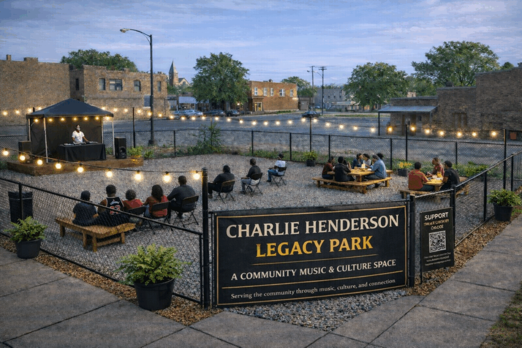
The proposal addresses a straightforward but pressing gap: many West Side young people lack safe, welcoming environments where they can gather, express creativity, and build confidence. Vacant lots that currently signal neglect become, with intentional activation, community assets. As programming gains traction, the space would expand to include youth workshops and broader organizational partnerships.
The model is also explicitly replicable. With modest investment and strong community involvement, the proposal envisions this approach scaling across multiple neighborhoods — a proof of concept for how small, community-driven development can create immediate neighborhood impact while honoring the cultural legacy already rooted there.
Neighborhood #6: South Side
Black Metropolis 2050: The Cap & Crown Project
Team Name: insīt
Lead Organization: insīt studio — Bronzeville, Chicago, Illinois
Michael Koto — Author & Civic Strategist; Founder, insīt studio and KMT Media
Black Metropolis 2050: The Cap & Crown Project is a sovereign community development plan for Chicago’s South Side — not a revitalization proposal authored from outside, but a completion plan authored from within, designed to resume an interrupted arc of Black cultural, intellectual, and economic life at a scale commensurate with what was systematically dismantled.
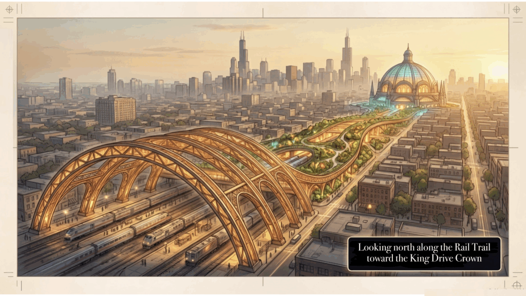
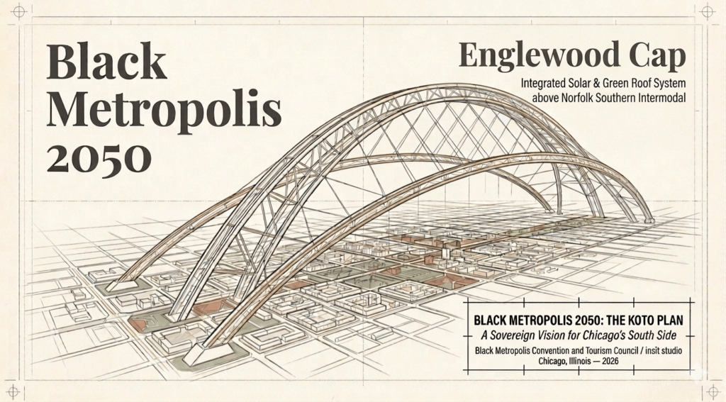
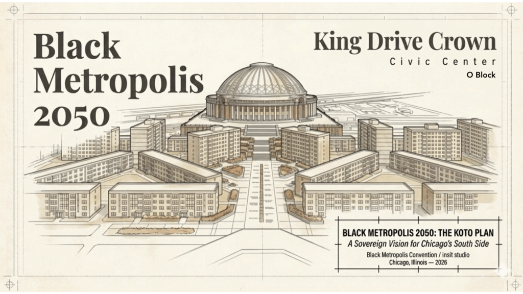
The plan is built around ten interdependent activations spanning the South Side from 26th Street to 138th Street, Lake Michigan to the Grand Calumet River. Its most audacious element is the Cap & Crown: a continuous elevated district above the Norfolk Southern freight corridor from 39th to 63rd Street — the rail infrastructure that has divided Englewood and Bronzeville for over a century. The Englewood Cap decks the 84-acre intermodal yard with green landscape, solar canopies, community-owned farmland, and 400 units of housing for families Norfolk Southern displaced. The King Drive Crown, a monumental civic building at 63rd and King Drive, houses a Great Hall, the Black Metropolis Archive, and the South Side’s first true intermodal transit hub — its dome visible from Lake Shore Drive and the downtown skyline.
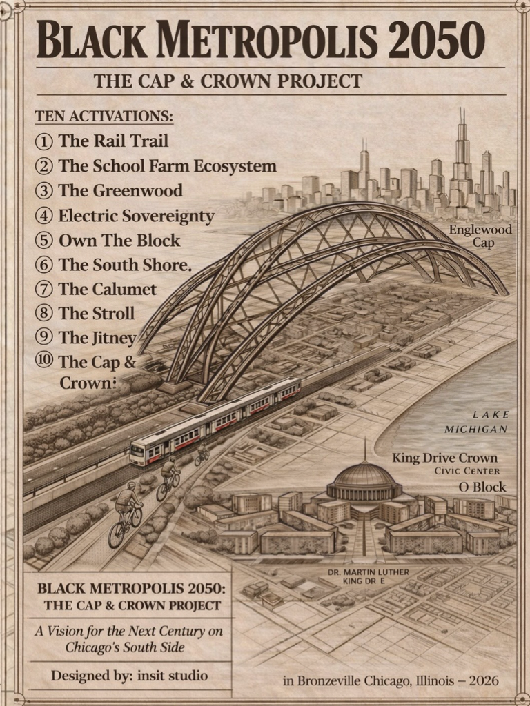
The remaining activations are equally concrete. A protected Rail Trail closes Chicago’s largest mobility gap using existing right-of-way. A School Farm Ecosystem converts 21 vacant school buildings into a community-owned food production economy addressing food deserts and youth unemployment simultaneously. An Electric Sovereignty initiative extends IIT and ComEd’s existing community microgrid into a full community energy territory. A community currency called Kowrie, backed at the South Side Community Federal Credit Union, functions as Chicago’s first municipally-partnered local economic instrument. And The Stroll unifies every major Black cultural institution on the South Side into a navigable year-round tourism circuit comparable in scale to the Museum Campus.
The plan advances on four simultaneous tracks — legislative, capital, development, and organizing — with several elements ready to move immediately. The IIT/ComEd microgrid already exists. The 21 vacant school buildings are available for acquisition. A dormant $3 million Norfolk Southern community benefit fund, committed during a 2023 City Council expansion approval, is designated as the Englewood Cap’s seed capital. The Illinois Quantum and Microelectronics Park has already broken ground.
Every element, the proposal argues, has a proven precedent somewhere in America. What makes this combination plausible now is that the infrastructure exists, the buildings are available, the seed capital is waiting, and the vision is documented at the scale and specificity required to act.
Neighborhood #7: Southwest Side
Sanctuarii City
Lead Organization: OASES
Jasmine Anwuli Michaels — Founder & CEO, OASES; Developer, Master Planner, and Project Lead
Germane Barnes — Principal, Architect Studio Barnes
Marquan Jones — Marketing & Communications
Isaiah Frandsen — Founder, Creative Director, Anu Breath, Health & Wellness
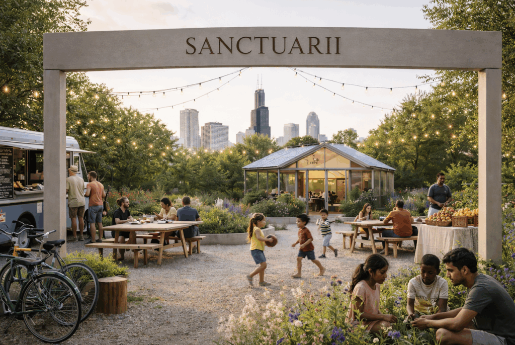
Sanctuarii City proposes transforming Chicago’s vacant lots into a citywide network of intentional green sanctuaries — dignified, beautiful community spaces connected by walkable and bikeable corridors that make movement across neighborhoods feel natural again.
The proposal begins from a pointed observation: proximity does not equal equity in Chicago. Residents on the same street but in different neighborhoods can face dramatically different health outcomes and life expectancy. Fear-based mental maps — “don’t go to the South Side,” “don’t go to the West Side” — function as real borders that shrink the city economically and socially. Sanctuarii City treats the built environment as both an economic regeneration tool and a public health intervention, drawing on global research linking green space access to mental health and the proven model of micro-forests — dense native plantings that restore ecology and create calm within urban intensity.
Each sanctuary is locally themed around community-identified needs: food access and outdoor kitchen programming in one neighborhood, cultural heritage installations in another, native rewilding and pollinator habitat in a third. The design principle is consistent across all sites — aesthetic beauty is non-negotiable, because dignity and healing depend on it.
The network grows through a chain model. Each new sanctuary is developed in sequence with the last, so connectivity expands continuously: first A to B, then A to B to C, until the corridors form a citywide system carrying residents across wards as explorers rather than commuters. By 2050, the goal is at least one Sanctuarii in every ward, linked into a single navigable network.
Governance is built around long-term stewardship rather than ribbon-cutting. Each sanctuary is co-managed by a foundation providing multi-year operating support and a local community organization providing daily care, programming, and neighborhood accountability — ensuring spaces remain living places rather than beautiful objects that fade.
The first pilot, the South Side Sanctuary in Bronzeville, has already been completed. The proposal’s ten-year horizon is grounded in a simple, replicable demonstration: three sanctuaries across three connected neighborhoods, measured and documented, then scaled.
Neighborhood #8: Far Southwest Side
The Grove
Team Name: Umsoco Provisions LLC
Lead Organization: Umsoco Provisions LLC
Alex Pate — Founder, Orchard Manager, and Project Lead
4th Ward Alderman Lamont Robinson — Political support
University of Illinois Extension — Advisor
DePaul University — Advisor
Advocates for Urban Agriculture — Collaborator
Bronzeville Alliance Community Garden — Community collaborator
NeighborSpace — Land trust partner
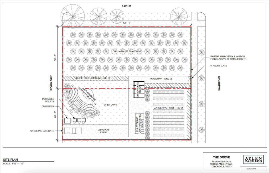
The Grove proposes transforming a vacant city-owned parcel in Bronzeville into a boutique agrotourism destination, working orchard, cultural venue, and neighborhood gathering place — reimagining what urban agriculture can be when it refuses narrow definitions.
The project plants a minimum of sixty fruit trees across roughly 15,000 square feet over three years, cultivating cold-hardy figs, cherries, peaches, and pawpaws alongside diversified annual and perennial row crops using permaculture design principles. By 2050, The Grove aims to produce nearly two tons of fresh fruit annually, feeding into a fully integrated local food system that includes a food hub, commercial kitchen, and e-commerce grocery store connecting Bronzeville residents directly to locally grown produce.
What distinguishes The Grove from conventional urban farms is its business model. Rather than depending on thin produce margins, two primary revenue streams drive sustainability: perennial fruit production and a curated programming slate hosted in a native-planted outdoor amphitheater seating under 100 people. Farm-to-table dinners, live performances, comedy, film screenings, and a garden spa concept featuring mobile saunas and cold plunges position The Grove as a genuine third space for neighborhood residents — a place to gather, decompress, and reconnect with each other and the natural world.
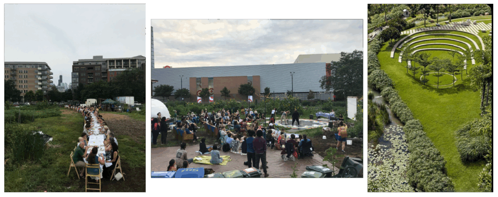
The project is sited along the future Bronzeville Trail corridor, making The Grove one of the trail’s anchor destinations — a place where the greenway’s ecological ambitions are fully realized, where visitors can step off the path into an orchard, hear music, learn about native species, and buy fresh produce.
Implementation follows three phases: orchard establishment and venue activation within five years, expansion to a food hub facility with commercial kitchen and e-commerce operations in phase two, and a multi-acre diversified production farm completing a fully integrated local supply chain in phase three. Umsoco is also exploring cooperative ownership models that would allow Bronzeville residents to become member-owners of the business — grounding the project’s long-term sustainability in community investment as much as philanthropic or public funding.
Neighborhood #9: Far Southeast Side
South Beach Chicago
Team Name: South Beach Chicago
Lead Organization: South Shore Chamber Community Development Corporation
Tonya Trice — Executive Director, South Shore Chamber of Commerce & Community Development Corporation
Jonathan Scott — Director of Real Estate Development and Urban Planning
LaShawn Brown — Special Service Area #42 Program Manager
Andrew Broderick / Perkins & Will — Architecture and Design
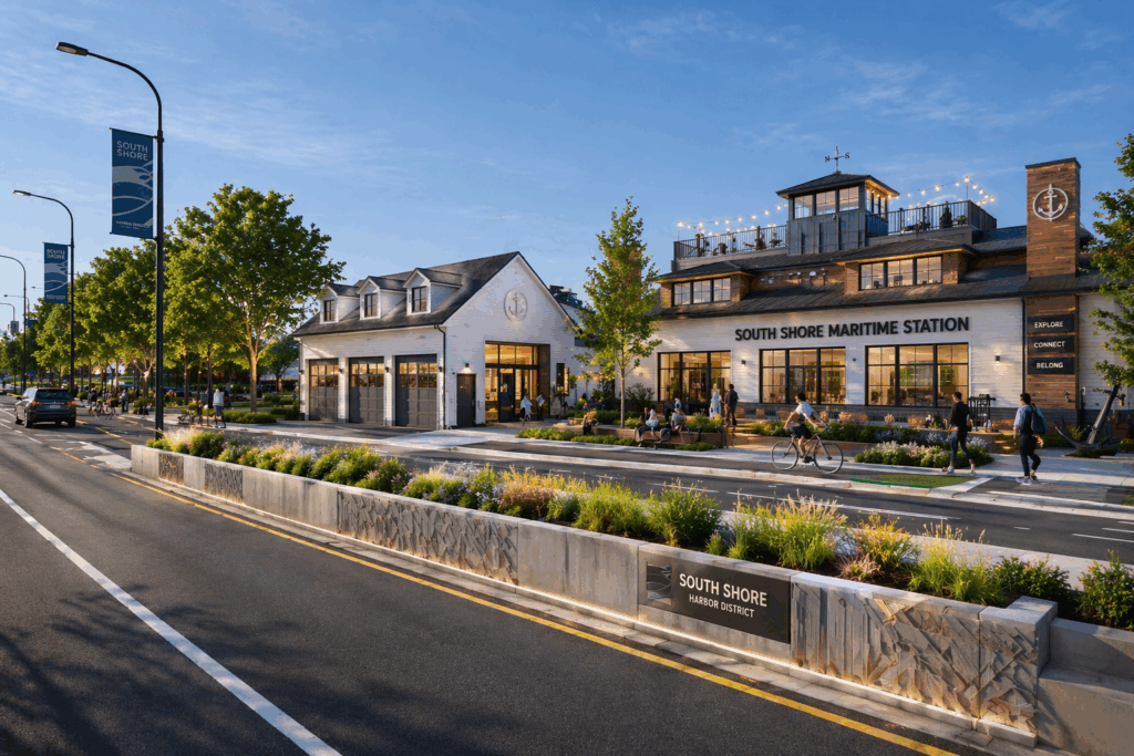
South Beach Chicago proposes transforming the southern lakefront from 57th to 79th Street into a vibrant, economically productive destination — repositioning the South Side’s shoreline as a regional tourism anchor and capturing the visitor economy that the Obama Presidential Center is poised to generate.
The proposal begins from a concrete economic diagnosis. Despite sitting less than half a mile from Jackson Park’s harbors, beaches, golf courses, and the South Shore Cultural Center, the surrounding community loses more than $845 million in consumer spending annually to areas with more developed amenity infrastructure. Without intentional investment, a significant share of the hundreds of thousands of annual Obama Presidential Center visitors will spend their dollars north toward downtown rather than in the neighborhoods adjacent to their destination.
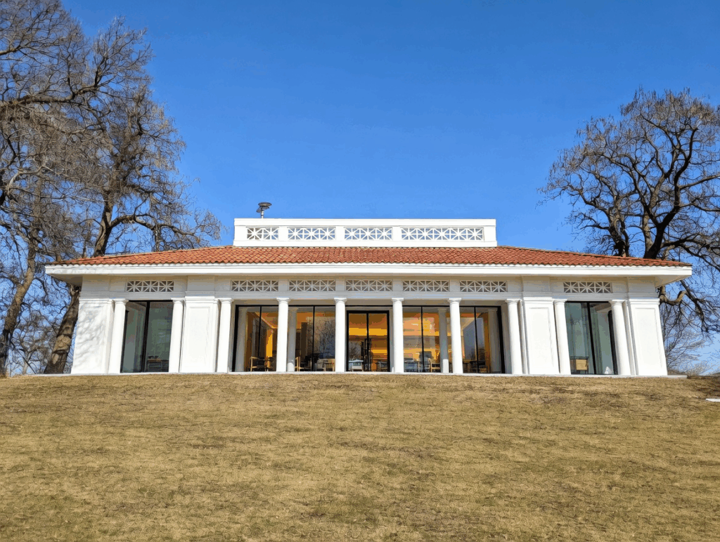
Three historic assets anchor the revitalization strategy. The Jackson Park Burnham Building, a fieldhouse dating to the early 20th century, would be reimagined as a modern South Shore Pavilion for year-round cultural programming. The South Shore Maritime Station, once a waterfront dining and boating destination, would be restored as a signature lakefront venue combining dining, entertainment, and water-based recreation. The South Shore Cultural Center — an iconic 1905 landmark operated by the Chicago Park District, and the site of Barack and Michelle Obama’s wedding reception — serves as the cultural and economic anchor of the entire corridor.
Implementation follows a three-phase, ten-year structure: planning and predevelopment in years one and two, asset rehabilitation and programming activation through year five, and private investment attraction and full tourism integration through year ten. The South Shore Community Development Corporation, currently leading a $28.5 million revitalization strategy for the 71st Street District, provides the institutional credibility and neighborhood trust to execute at this scale.